Five Minutes Understanding#
This section delves into the project’s origins from CDWS and provides insights into the significance and straightforward understanding of the DC-resistivity methods during the campaign for drinking water supply (CDWS).
What are ERP and VES?#
Electrical resistivity profiling (ERP) and vertical electrical sounding (VES) represent subsurface geophysical imaging techniques favored for groundwater discovery during CDWS, particularly in developing nations. These methods are chosen for their affordability and suitability in sedimentary environments. Typically, ERP is employed first to identify conductive zones (anomalies) based on criteria such as anomaly shape, type, and local geology [1]; [2]. Following this, VES is used to infer the presence of fracture zones and determine layer thicknesses. The combination of these methods aims to locate the most favorable drilling site expected to yield a flow rate at or above the required flow rate (RFR).
Why is RFR crucial in CDWS?#
The RFR is directly linked to the hydraulic system design, which depends on the population size within the target locality [3]. For instance, a village hydraulic system (VH) is typically recommended for populations under 1000 (\(FR\geq 1 m^3/hr\)). For populations between 1000 and 4000, an improved village hydraulic (IVH) system (\(FR\geq 3 m^3/hr\)) is suggested, while urban hydraulic systems (UH) (\(FR\geq 10 m^3/hr\)) are designed for larger populations exceeding 4000 ([4]; [5]; [6]). Consequently, drilling that yields a flow rate below the RFR is deemed unsuccessful, necessitating further geophysical surveys in the area. This process not only incurs additional costs but also poses significant challenges in adhering to project timelines, a puzzle that many local companies strive to solve.
What traditional techniques/tips are used to solve the unsuccessful drilling?#
Local companies typically propose up to three drilling locations, ranked by priority after the survey, to maximize their chances of achieving the required flow rate (RFR). However, the strategy of suggesting multiple drilling points does not always guarantee success, and locating the optimal drilling site to meet the RFR continues to pose significant challenges.
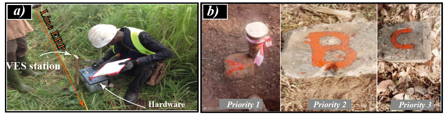
DC-resistivity methods. a) ERP and VES investigations. b) Priority for drilling operations based on traditional methods.#
How traditional techniques mitigate unsuccessful drilling ?#
Traditional methods to reduce unsuccessful drilling risks typically involve a blend of initial surface assessments, analysis of historical data, and the incorporation of local geological insights. Practices such as geological mapping, soil sampling, and the use of anecdotal evidence from community water wells are instrumental in gathering crucial pre-drilling information. Furthermore, tailoring drilling strategies to the specific subsurface conditions encountered, alongside applying empirical formulas rooted in the local geological and hydrological context, has proven effective in improving drilling success rates.
Grasping these conventional techniques is essential to recognize the enhancements
brought about by watex. Merging contemporary machine learning algorithms
with established geophysical approaches, watex elevates the precision
of groundwater discovery processes. This significant improvement in predictive
accuracy diminishes the chance of drilling failures and also ensures a more
efficient use of resources, paving the way for more sustainable water supply solutions.
What’s novel about using WATex in GWE?#
watex introduces “smart” algorithms, including pre-trained machine learning
models from watex.models.pModels, to predict feasible FR before
initiating drilling operations. This innovative approach aims to enhance
traditional geophysical methods, decrease unsuccessful drillings,
minimize unsustainable boreholes, and reduce financial losses. Additionally,
when constraints, such as site restrictions, are inputted into the
watex.methods.electrical.ResistivityProfiling class, watex can
advise whether the auto-detected station is suitable for drilling. It also alerts
users about selected stations near restricted areas, thereby informing decision-making
processes effectively.
Addressing the GWE challenge during CDWS has been a cornerstone
in the development of the watex project.