Project story#
Here is a story that describes the watex project design.
Introductory notes#
Water is a vital resource in the world, and the issues related to water of this present century remain crucial faced to the climate change challenges. Water, in addition to being used in industries, electronics, services, and companies, remains a rare commodity, especially for developing countries. Indeed, water treatment is very expensive and only developed countries have the means to afford the final treatment chain.
The idea of the project was born in 2015 in the geosciences and civil engineering operations company (IBS+). In this venture, I was selected as a geophysicist engineer where one of my missions consisted to bring potable water to many regions of Cote d’Ivoire and beyond. An tangible example outside CIV was the CDWS in some West African sub-regions such as Niger, Guinea, Mali and Burkina. These different projects were partly funded or bi-supported by international organizations (World Bank, UNICEF ) and the host country governments (e.g., PNAEP and PPU programs in the case of CIV) with several cooperation initiatives.
Trigger effect#
Althrough, the desire to enhance the living conditions of the population remains one of my main concerns, the trigger factor
that accelerates the design of watex was the Diacohou-Nord project in 2017 ( in the center part of Cote d’Ivoire, see Figure 1).
The project was specific which purpose was to find the best location for the drilling operations expecting to obtain a
flow rate (FR) of \(10m^3/hr\) (= RFR). However, this peculiar area strongly faced with a drinking water shortage
especially during the dry season. The condition such as the topographic/terrain and other constraints were not optimals to get such FR thereby worsening the
conditions of the living populations. In addition, during our trip to that locality, from 6 P.M. to 6 A.M. every day, women in the village rush away
into the forest for seeking potable water for the households, their husbands, and their children ( Figure 1.a). The water flowing from
the lowlands, mash areas and rocks located far in the forest entailed the second alternative source of water when all the wells/boreholes
in the locality and surrondings had dried up notwithstanding the dangers with the wild animals.
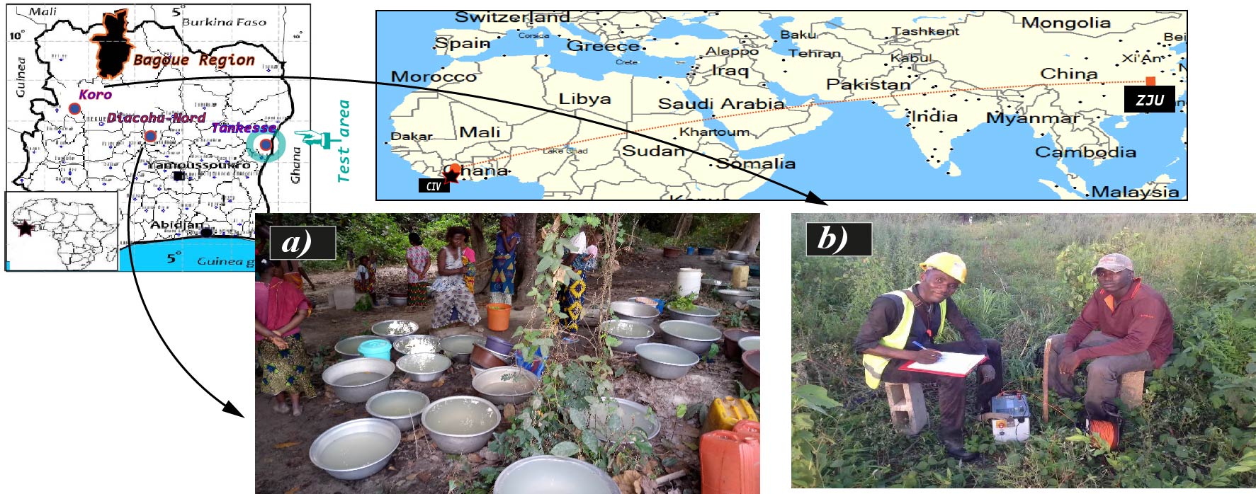
DC-resistivity survey investigations. a) An illustration of the critical issue of water shortage in Diacohu-Nord. Women are waiting for water in the forest from night until the morning. b) DC survey investigations in the “Koro” locality, north area of the Cote d’Ivoire#
Unfortunately, the consequences of that water quest at night in the forest were numerous and terrible such as the snakebites that I witnessed on May 17, 2017. The lady was immediately transported to the nearest city for treatment. I was upset to hear that this phenomenon seems common experienced and frequently happened in their daily life.
On my return from the mission, I, therefore, thought to solve this problem so that such a story does no longer happen again. Thus, two months later, I resigned from the company and looking for a scholarship opportunity to study in programming and artificial intelligence. The first idea that came to mind was to design a machine to detect an underground water reservoir capable to estimate the FR according to the population needs even in dry seasons.
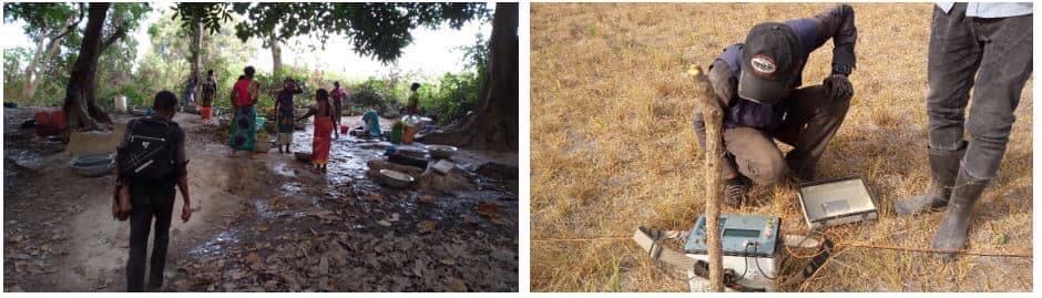
Women are seeking for drinking water: left-panel) The place where the lady was bitten by the snake. Early in the morning, my team and I went to the site for inspection to propose an alternative solution ; right-panel) survey investigation in Diacohu-Nord locality. The color of grasses shows the drastic consequences of the dry season in this locality.#
Fortunately, three months later, I got a scholarship from the China Scholarship Council (CSC)
of the Chinese government in collaboration with the government of Côte d’Ivoire for a Ph.D candidate. Thus, I was registered
to Zhejiang University (ZJU) in 2018 where I my research interest was computational geophysics.
My research work entailed to design new ML approaches capable to detect the fracture zones and predict FR efficiently
from DC-resistivity and electromagnetic (especially the CSAMT) data. Thus, the first trial version of watex
was born. It was focused on a case study problem in the Bagoue region ( see Figure 1.). The results were satisfactory with a
prediction score of 77% of correct FR with a reasonnable amount of data.
Efficiency test#
To test the efficiency of the software in other locality (out of Bagoue region), we, therefore collected data from a local company
GEOTRAP SARL
in the region of Indenié Djuablin, named Tankesse (East of the CIV, see Figure 1.).
The data were processed and fed to the software algorithms (watex.methods.electrical) to auto-detect the favorable stations
(in blue) and select the best one by adding the environmental constraints as shown in the figure below. The goal was
to predict the RFR estimated to \(5m^3/hr\). As a result, watex proposed, as the final drilling point( the best),
the station S53.
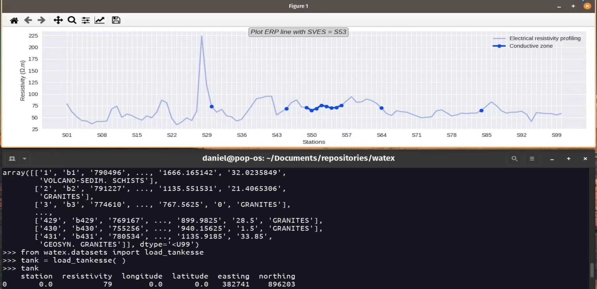
Tankesse data processing. Data collected from GEOTRAP SARL.#
Fortunately, two months later, the drilling was successfully carried out yielding a FR of \(9.7 m^3/hr\) whereas
watex predicted \(7.3 m^3/hr\) (see video ). Indeed, this seems
truthy because the “smart” algorithms implemented in watex do the essential to not overestimate the
groundwater FR prediction. The aim is to minimize unsucessful drillings and therefore reduce expenses.
Here is a youtube video that shows the efficiency of the use of software for future
CDWS.
It was a great chance for the popualtion living in this area since the Tankesse area (get data from watex.datasets.load_tankesse())
has significant thick layers conposed of granitic arenas which often give a wrong rate of FR during/after the drilling operations
based on our traditional methods thereby causing the numerous unsucessful drillings and unsustainable boreholes.
Artificial intelligence (AI) via watex could just taken up its first challenge for the population
welfare in this region.
Conclusions#
watex is less expensive tool because it uses cheap geophysical methods (ERP and VES) to predict the
expected the FR which is related to the number of people living in a given locality for a long-term water exploitation.
For example, suppose that a population of a given locality of 2,000 inhabitants increases in 10 years to reach 50,000 inhabitants,
the RFR of \(3m^3/hr\) today (with 2,000 inhabitants) will no longer be valid within 10 years due to the population
growth and the effects of climate change. From now on, watex seems an alternative solution to reduce the
rate of unsucessful and non-sustainable drillings.
Beyond this aforementioned problem purely related to hydrogeological exploration, watex offers other exploitable assets
and hopes in the next five years to become an important library in the GWE field with with the participation of diverse of
constributors of to this project hopefully.
See also
five-minutes to understand the project genesis.
Credit to the author.